| May 18, 2003 Farallones Event |
This web page is a compilation of various emails, pictures and data about the planned cruise to the Farallone Islands, and the actual result. There were over 25 boats that expressed an interest in going - by far the largest fleet for any cruise. It was unfortunate that Mother Nature didn't cooperate!
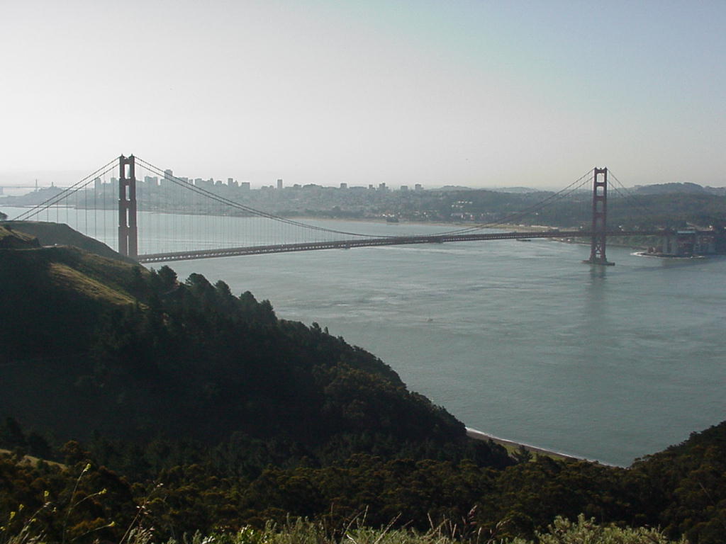
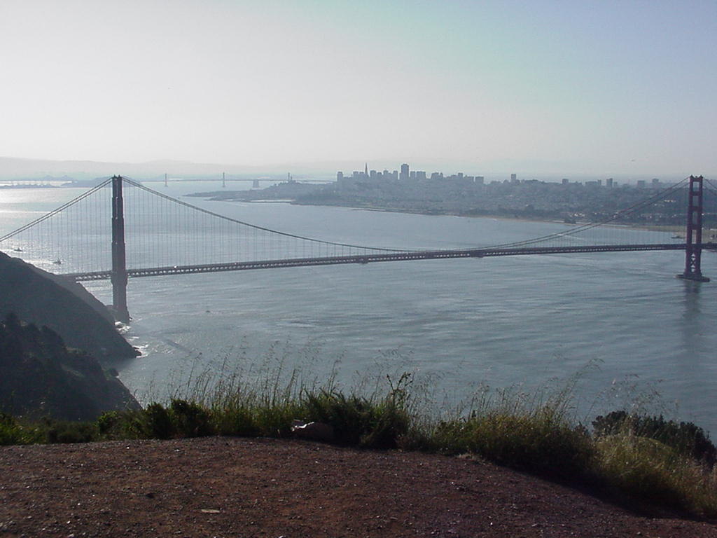
We hope you will enjoy reading it from top to bottom, but we've provided a Table of Contents since this is a large page. Enjoy this glimpse of the rugged San Francisco Bay entrance. Pictures on this page were taken from .5 to 1.5 miles away and therefore are large to retain more detail, so they may take longer than usual to load - they are well worth the wait! You can click even the larger pictures to get a full-screen version. We hope we will receive some pictures taken from those few who actually put to sea to add to the collection.
From Robert Aston, "Pegasus":
 It was a most beautiful 0630 morning on the Bay: the sun, a brilliant yellow-orange, just rising from behind the Oakland Hills; the dark blue, reflective water looking cold, yet calm; not a white opaque wisp of fog, to be seen; and there was the gentlest of breezes, barely discernable, upon the cheek.
We left the harbor of the Golden Gate Yacht where Pegasus had spent the night, and made our way towards the Gate. Along the way, we passed, or were passed, by numerous craft - some, like us, just starting there day, others, well into theirs, heading to places, possibly countries, unknown. Ahead of us lay the Golden Gate Bridge, still well lit, beckoning us towards that great opening, that leads to the rest of the world.
The closer we got, we noticed two familiar rigs, much closer to the Bridge than us. The feeling of fellowship welling, we scanned the rest of the Bay, for signs of other Islander 36's. No joy! We remained hopeful, more would join us.
I had followed the NOAA broadcasts for the past 24 hours. It had not changed much, but there was also a bit of leeway. Despite the Gale warnings from Pillar Point, north to Point Arena, the conditions at San Francisco Buoy were: winds 14, gusting to 23, with combined seas of 14 feet every 11 seconds; the Farralones were much the same, except combined seas 12-16 feet, every 9 seconds; though at the Golden Gate, winds were West South West at 6 knots.
My crew consisted of my girlfriend, and my father. My father has spent years at sea on ships and boats of all sizes and configuration, and weather; I have done my fair share of sailing on everything from tall ships to Lasers in quite a variety of weather; and my girlfriend, quite the opposite, very much the novice, only having spent a very few warm, and wonderful, days on the Bay.
 As we passed under the Bridge, the waters swirled as Ocean met Bay, eddying around the precipice guardians that make up the Golden Gate, not to mention the bridge towers themselves. A few hundred yards out, the gentle rolling swells of the ocean, began to make their appearance.
Originally, I had planned to set sail just before the Bridge, and to sail out in the full glory to any sailor. Having seen our compadres ahead of us, I decided to keep motoring until we were in a cluster of I36 kin. The plan had been to go to those distant Islands together, and I felt at least we should start together.
Running at under 2000 rpm, I was amazed to note on the GPS, that we were zipping along well over 10 knots OG (Over Ground). We were slowly, but without a doubt, catching up with the two boats ahead of us.
Attempting to communicate with them, I found my hand-held VHF, one of them blue and white jobbies, often on sale, to be all but useless (not to mention any brand names). The mic cord for my on-board, was just a little too short, to be useful.
At about a mile, or so, outside the gate, one boat hoisted sails. The lead boat kept motoring. I though to keep motoring to ascertain how the sea state was going to resolve itself. We continued to zip along on the combination of ebb tide, and current.
 Despite patches of relative flat, the seas continued to build. The further out we went, the higher, and closer, the seas were. By approximately mile 4, combined seas were around 14-16 feet, at what seemed to be every 6-7 seconds. The tops were breaking on about +/- 30% of them. It was not the most comfortable time I have had at sea, but definitely not the worse. It was time to turn for home. At least, the shelter of the Bay.
Finding a comparably flat spot, large enough to make the turn and not get broad-sided, we made for the North side of the Gate.
 Naturally, our speed was nowhere near our departure speed. Surfing the waves in, and watching the engine RPM in the following seas, we still made good 3-4 knots OG. Even still, it seemed forever to get past the "Potato Patch" (officially known as Four Fathom Shoal) buoy.
Just outside the Golden Gate, we met up with Vivace. We managed to raise them on the radio, and related the conditions we had encountered. They thanked us, and decided to see for themselves. We did see them later in the day, sailing on the Bay.
 Once within the calm of our wonderful San Francisco Bay, we set sail, turned off the engine, and doffed our foulies, for another excellent day of sailing in Paradise. Warm weather, blue skies, and for the most part, fair winds.
As a follow-up, by the time we reached Alcatraz, the two other I36's that we had followed out, were back in the Bay. Our fleet was safe.
Sincerely,
Robert Aston
Pegasus
Go To Top
Sandy & Jack Thompson, "Noncents" (Freeport 36)
 I think Noncents was tied for the first boat out under the bridge.
We motored (with main sail up) out approximately 5 miles past the Golden Gate Bridge before reaching the same conclusion that the seas were getting very uncomfortable.
 Likewise we found a suitable time to turn around and motored back in, which took a little more time as it was still ebbing. From there we had a nice sail around the bay and went home.
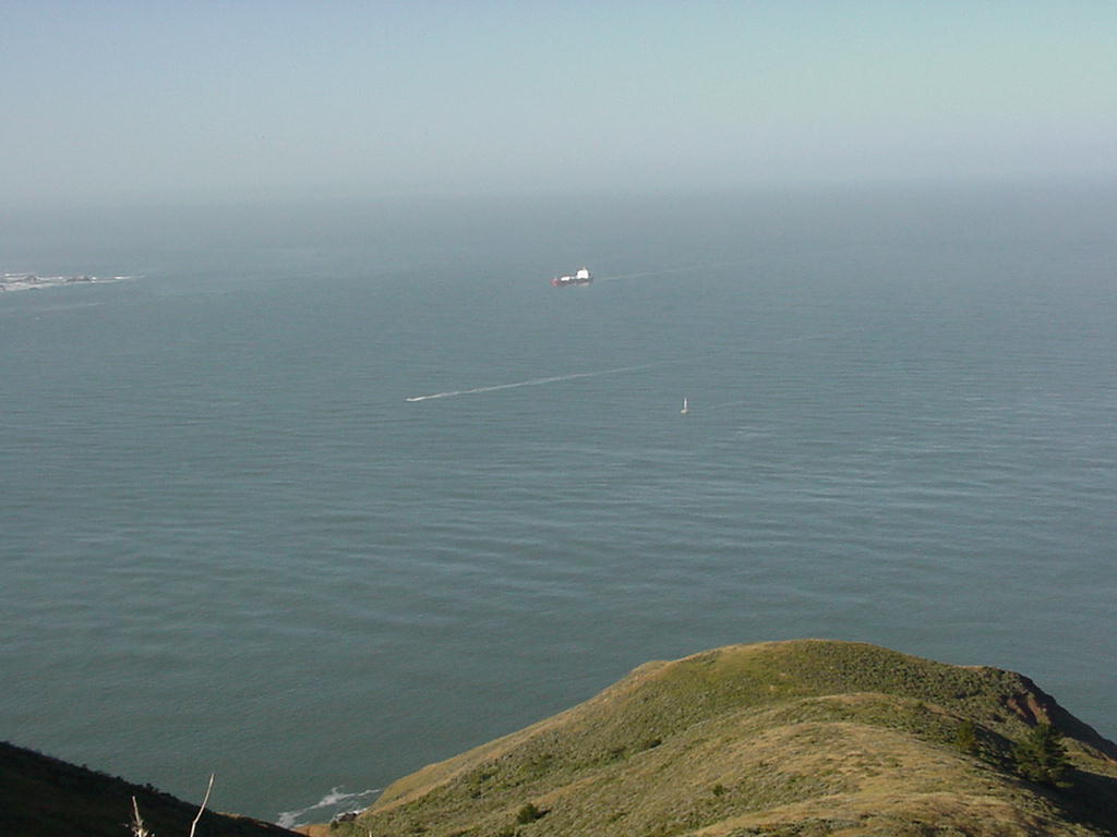
Sandy and Jack Thomson
Noncents
Go To Top
Tom Furlong, "Vitesse"
I left my berth at SFYC at about 6:15. I was going to go directly across to the GGYC, but the current said otherwise. I decided to just head for the gate in company with a Freeport 36.
There were at least two other Islander 36s in the distance. I was flushed out the gate by 7:00, still under power. The wind was light. Over the noise of my pathfinder, I believe I caught the end of the chatter from those at GGYC who decided to forgo the trip, but as there seemed to be several of us attempting it I decided to press on.
Once out the gate I started sailing, a number three with a full main. The wind was still light. Those under power pulled out ahead. Per your advise I stuck to the center of the traffic scheme and away from the potato patch.
 We made it out about four miles beyond the gate when it was apparent our other companions were giving up one by one. Since there didn't seem to be any company, I decided to do the same. The conditions at that point were still lights winds, but the swells were definitely getting quite large.
Back in the bay the day was beautiful with incredibly flat water. Maybe it just seemed that way because of the swells outside the gate. At any rate it wasn't a total loss and I would like to attempt the trip again.
See you soon.
Tom Furlong
Vitesse
Go To Top
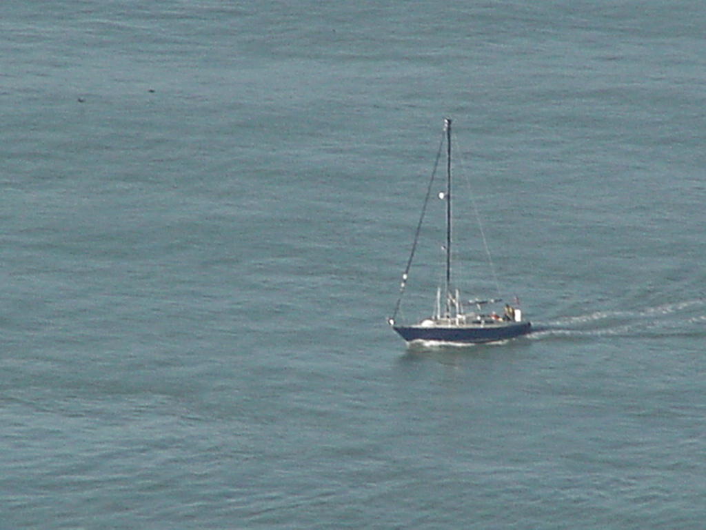
Dave Morton, "Vivace"
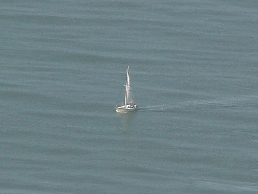
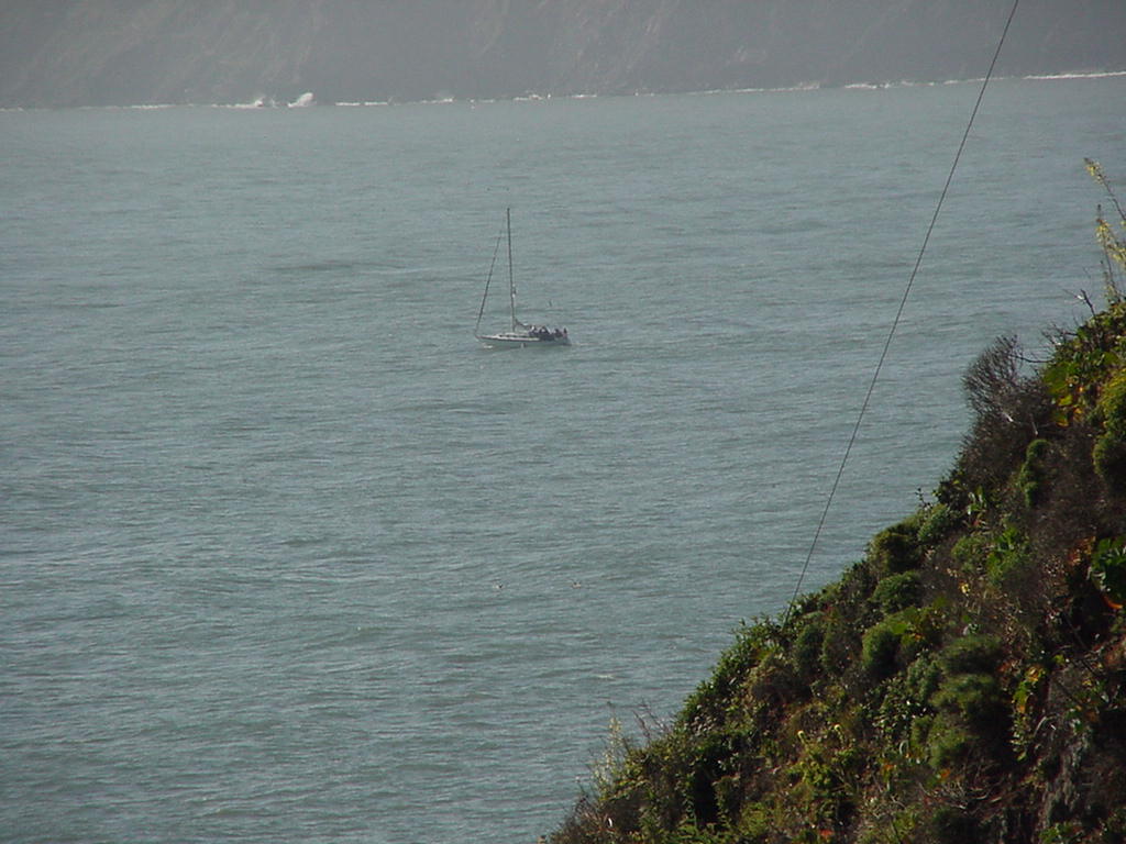
Though Dave didn't write his own words about the trip, he called in at 0625 and said he was on his way. Though your writer tried to make cell phone contact while taking pictures from the Marin Headlands, we never made a connection until late in the day. The pictures though, record the conditions that Vivace and the others sailed through, and capture Vivace heading back past Pont Bonita and returning under the Golden Gate.

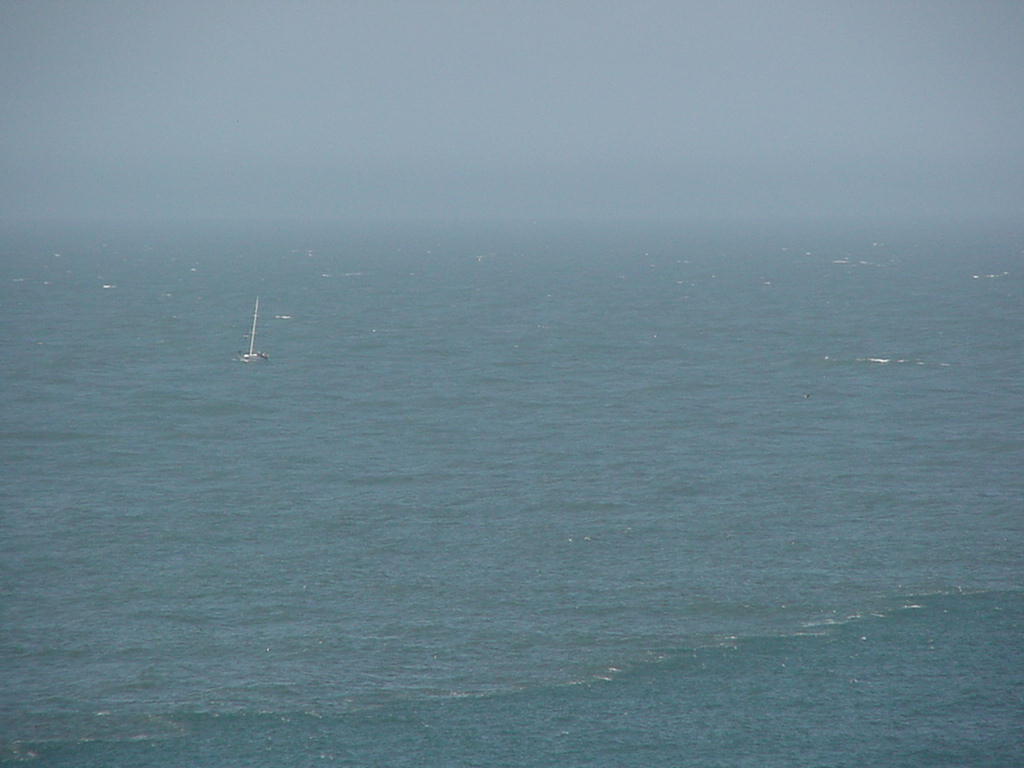
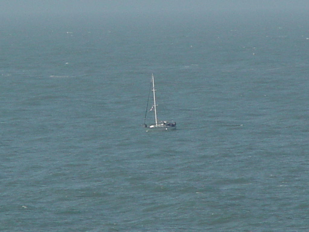
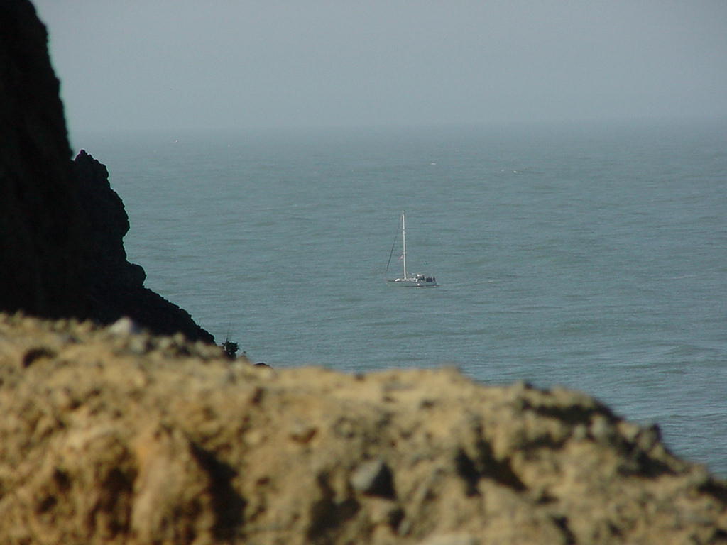
Tiny Stick Rolling Potato Chaser Brugee Flies At Bonita
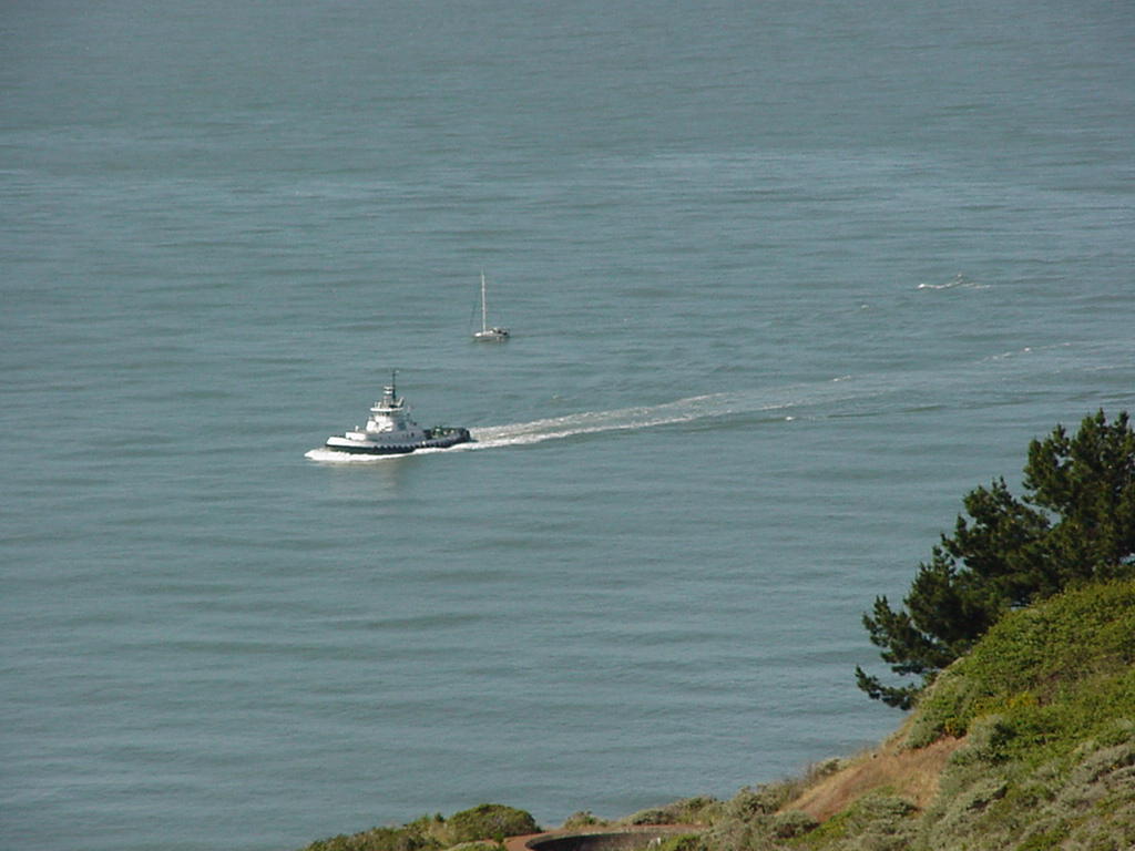
Safe Inside Zoomed An Escort! Finish In Sight Safe Home
Go To Top
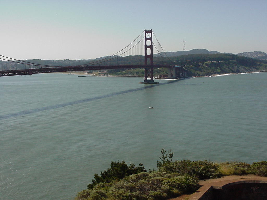
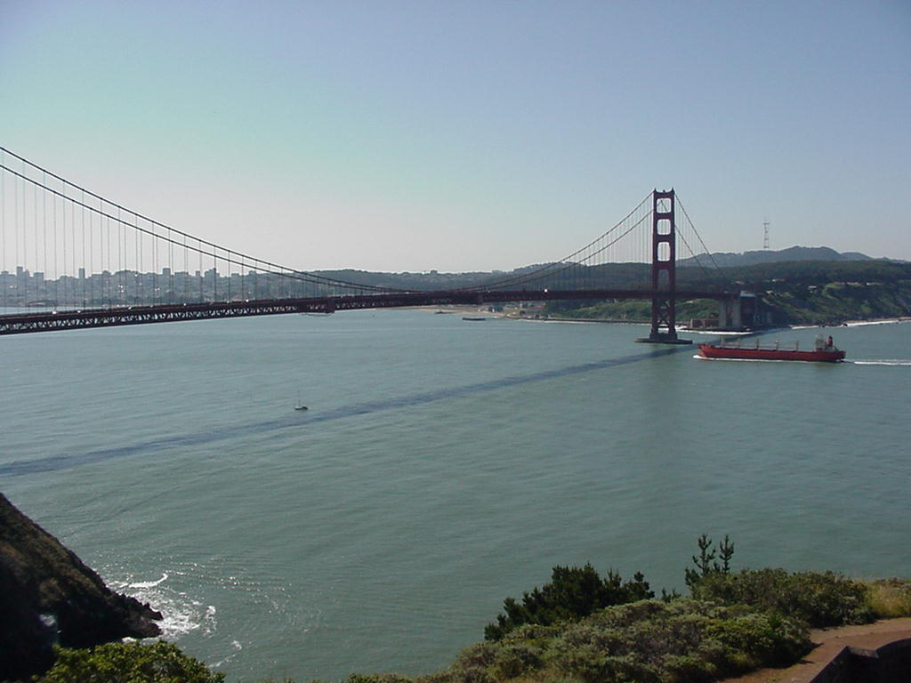
Some pictures from the Marin Headlands of the passage to Point Bonita, ship traffic, and one or another of the above returning. (Click on them for larger versions.)

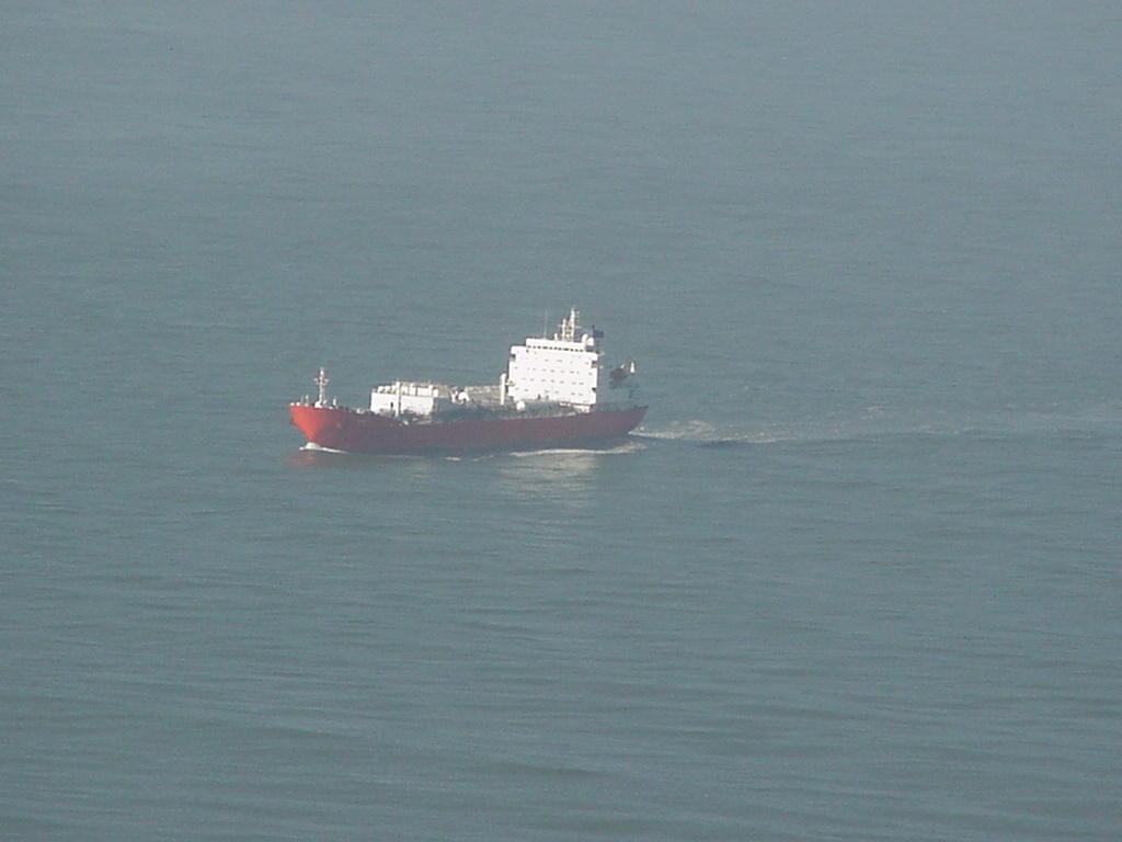

Never More! Inbound Big Red # 1 Bonita Light Radar Tower
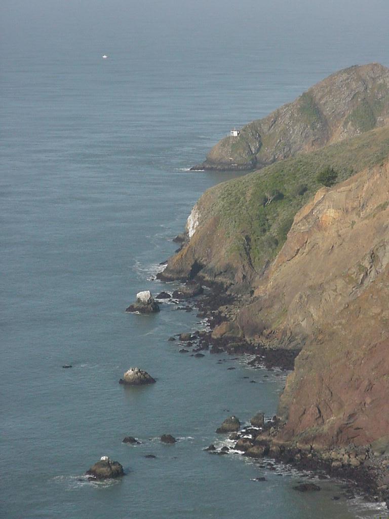
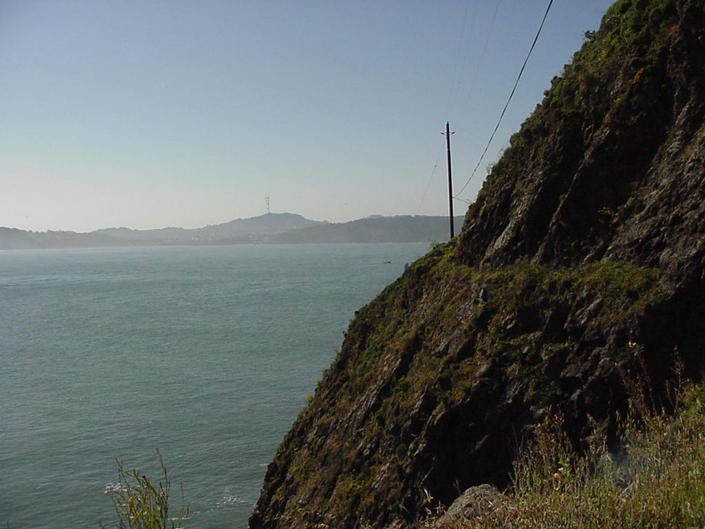
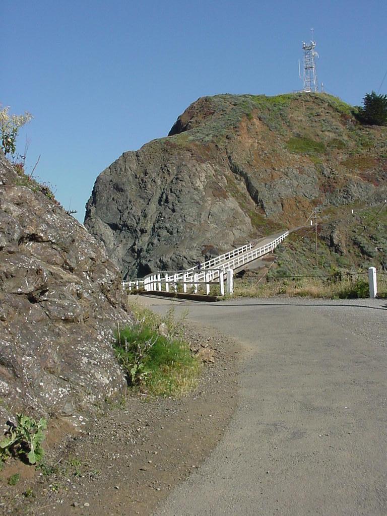
The Marin Headlands were once fortified to protect the entrance to San Francisco Bay. Here are both some pictures of their remains, and descriptions of the evolution of the navigation aids along this rugged stretch of water. . (Click on them for larger versions.)

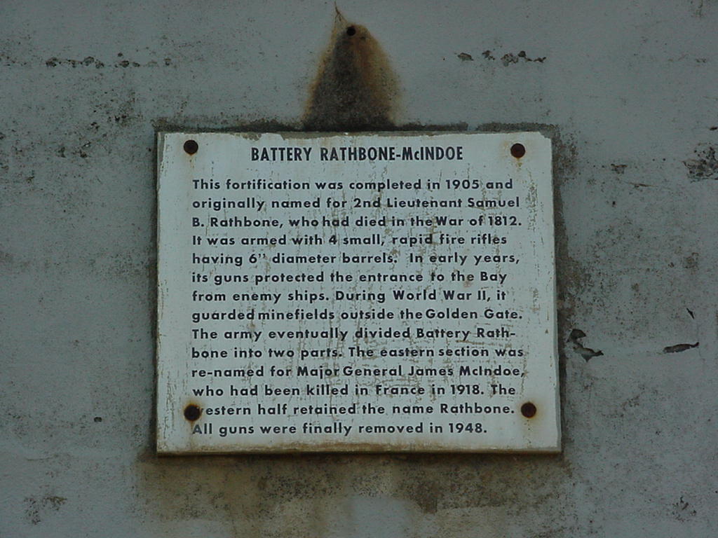
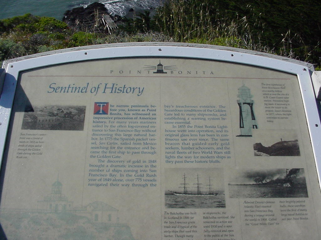
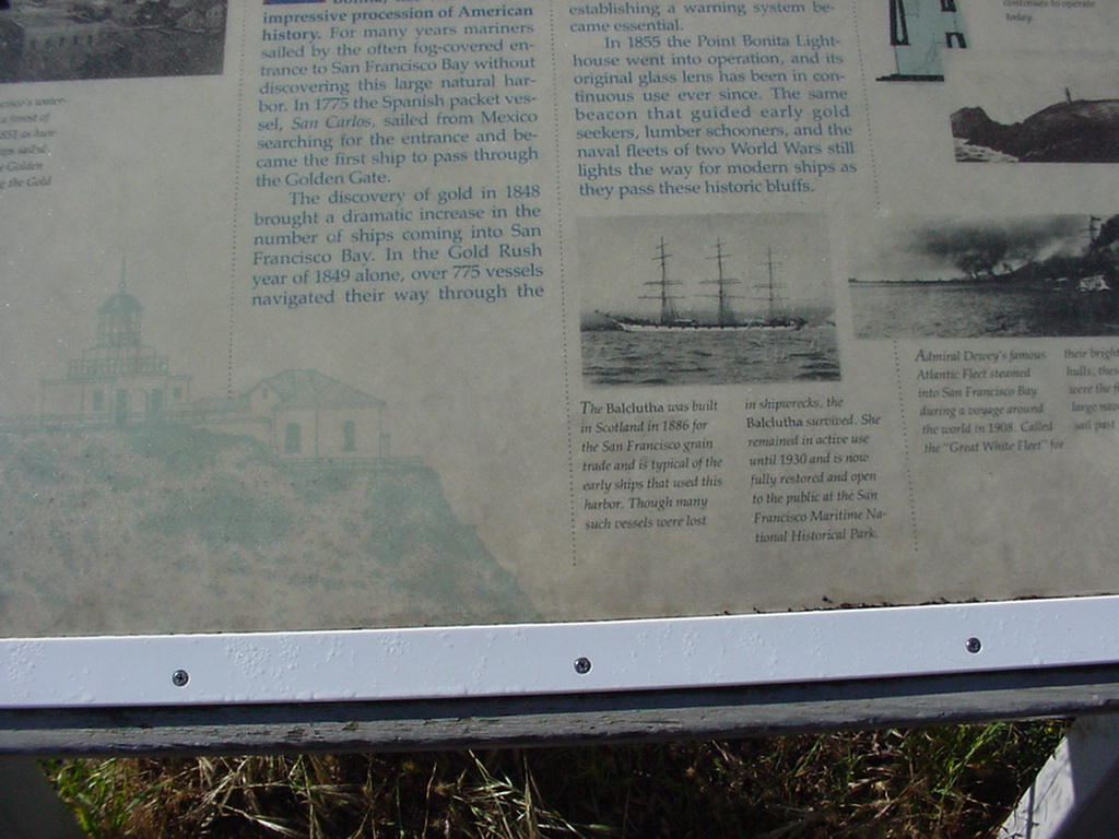
Battery Rathbone Sign First Lights Detail of Sign
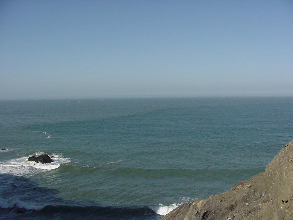
At rugged and beautiful Point Bonita the waves break on the outside, and there once was a rescue station inside. (Click on pictures for larger versions.)

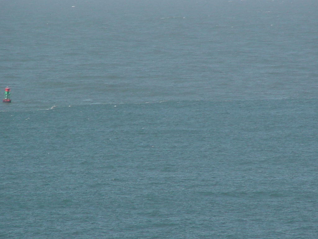
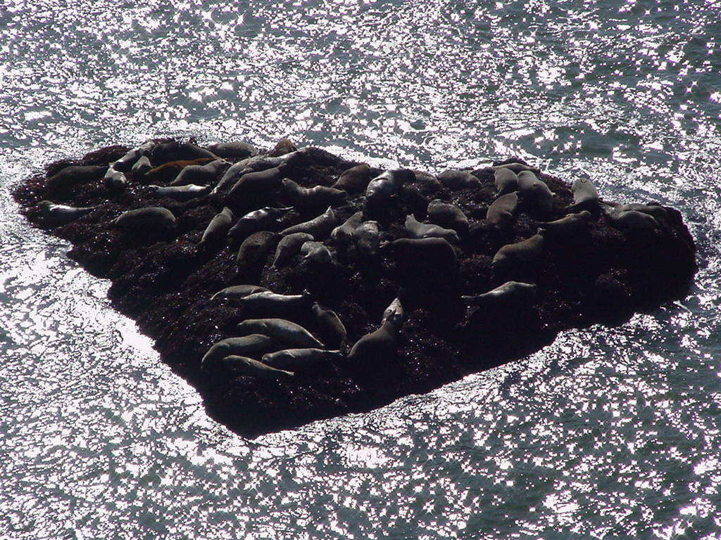

Danger! 1st Buoy Piniped Pack Thistle
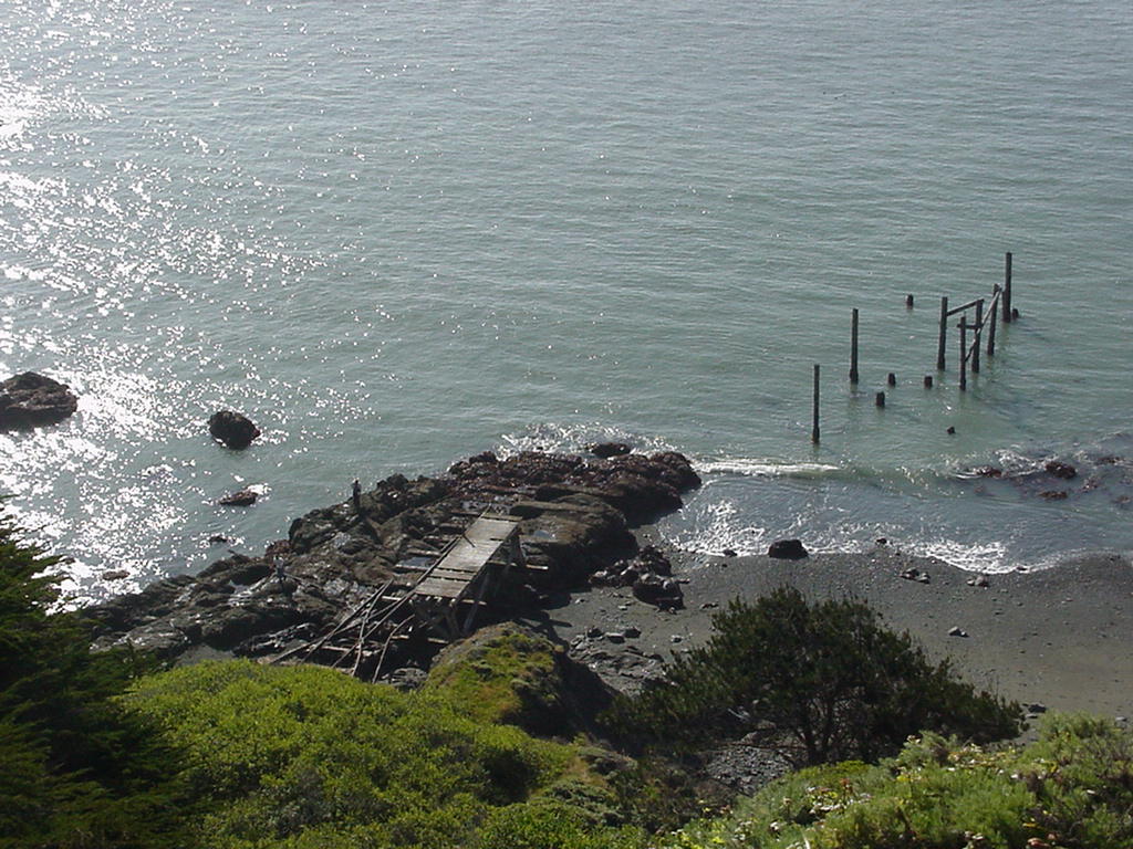
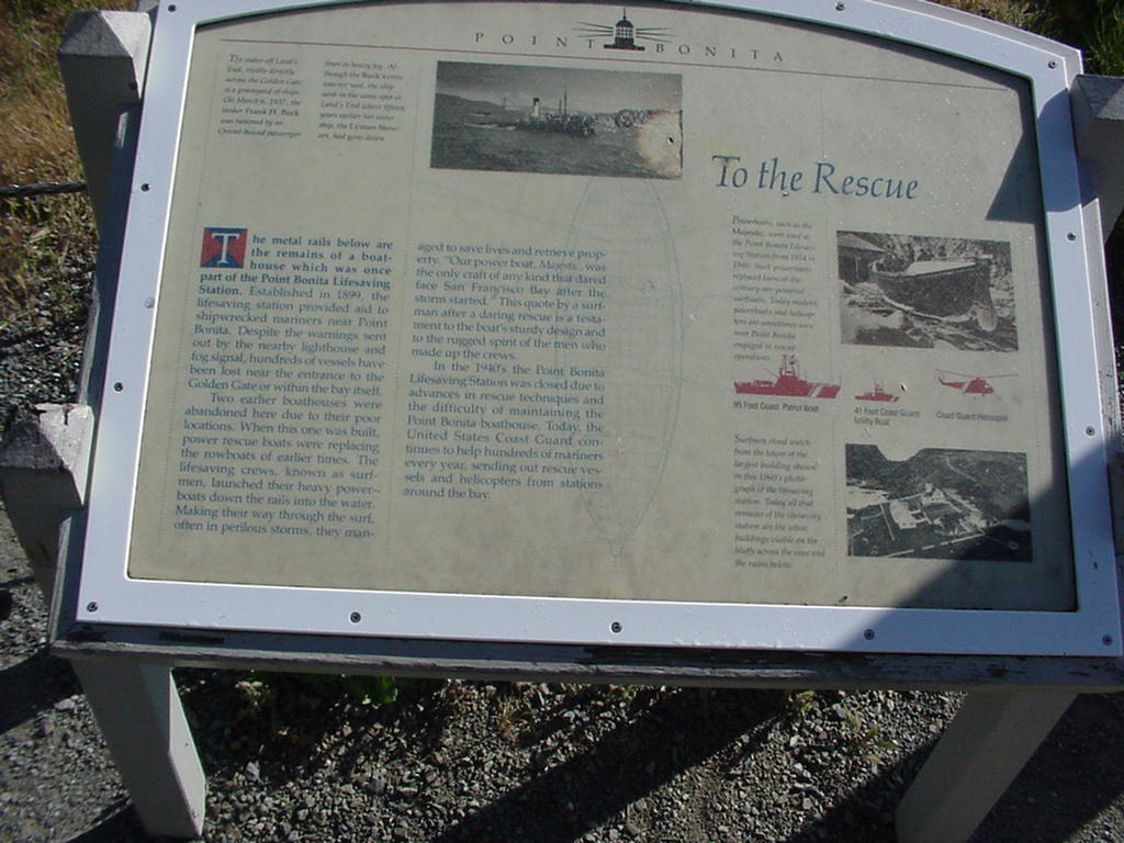
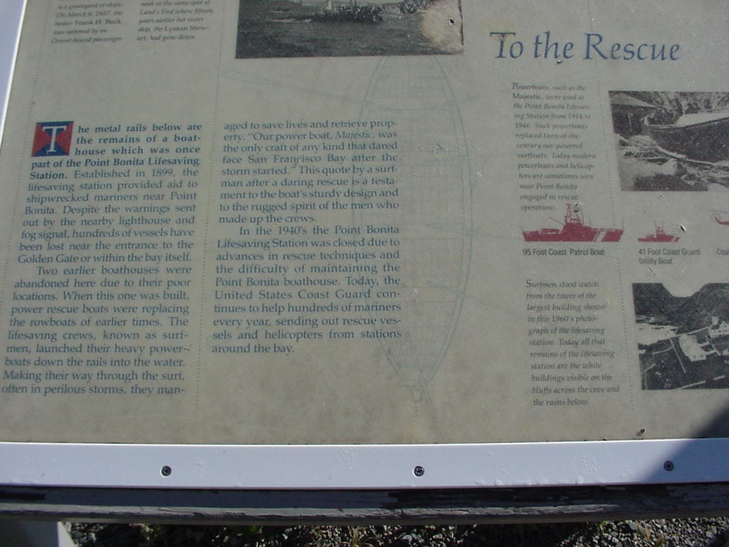
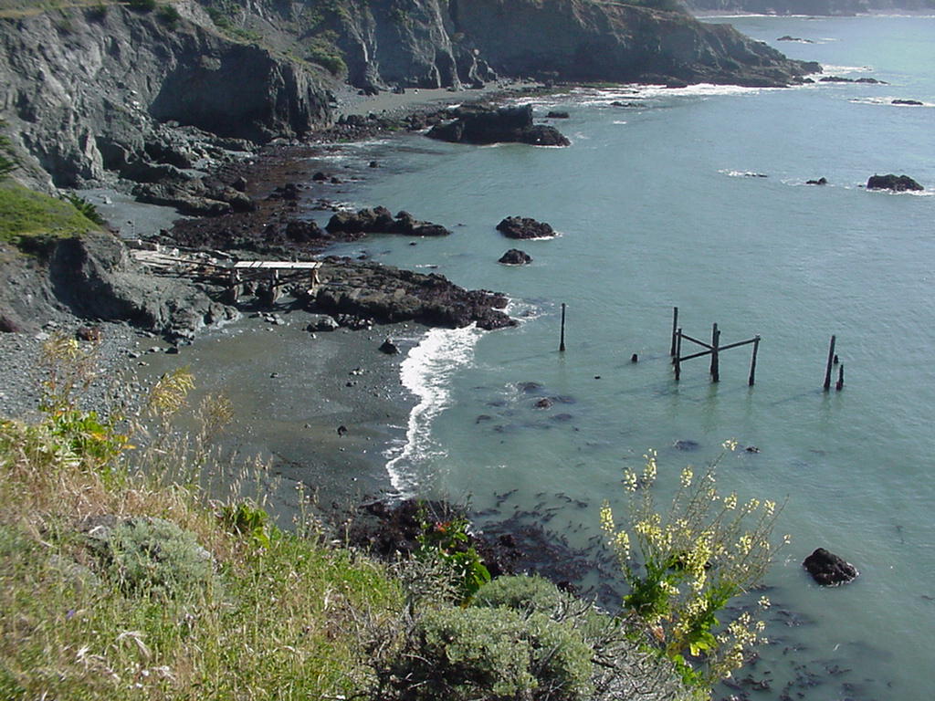
Old Railway Rescue Sign Sign Detail Remains
Go To Top
Michael Daley, "Laughting Matter"
Being aware of the -1.7' tide the morning of the 18th, I had talked to the Harbormaster (who is helpful and usually correct...) and got permission to move Laughing Matter from her slip (where she sits on the ground during any minus tide) to outside the new breakwater, and tie up to the giant cleats out there for the night, next to the sign prohibiting tie-ups. Unfortunately there was not a whole lot more water there, and it was nearly 10:00 before we floated clear. We spoke twice with Vivace from the mud in the morning on 72, but couldn't raise her later on in the day.
We passed under the Bridge at 10:30 and according to our plan, motored up the Bonita Channel, inside the Potato Patch, up to between Muir Beach and Stinson Beach. We saw one sail out to sea. From there we were able to shut down the motor and sail on a bearing for SE Farallon. It was clear it was too late to get there that day in the actual wind conditions, which were 12-15 Kts or so. There is significant Southerly current there, sweeping toward the Potato Patch, so the course to steer is considerably North of the bearing. It was clear, although the Farallons themselves were not visible through fog further offshore, and we got a nice view of the headlands. Seas became somewhat lumpy, but we were able to hold a fairly comfortable angle off the bow. After we bore North of the Westmost green buoy in the GG entry channel, we headed down for that, then back along the edge of the channel for the Bay. It was a nice sail, with great scenery and nothing like the predicted conditions in the area where we were, much of which is protected somewhat by Pt. Reyes.
Let's try again!
Michael Daley michaeld@pon.net
Laughing Matter
Go To Top
Weather Data
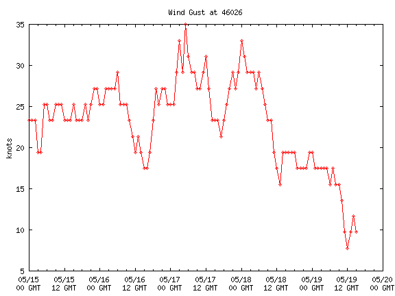
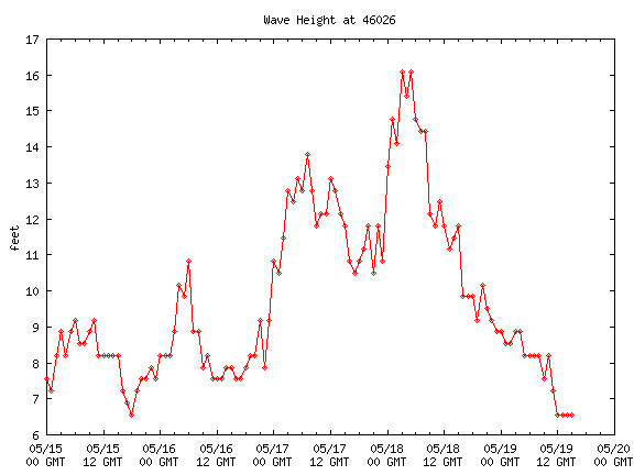
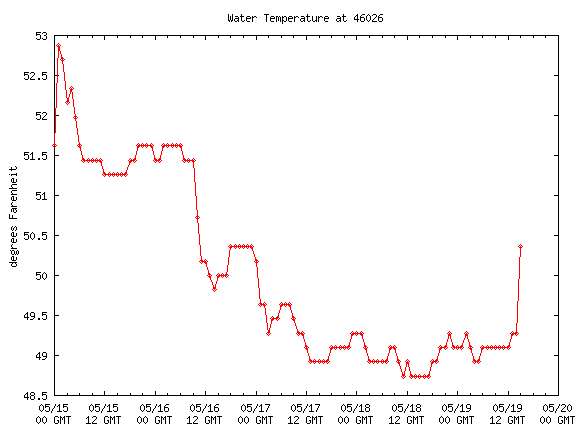
All those seas were the result of gale force winds which dropped off almost abruptly around midnight Saturday night, and though the seas started coming down from their 16' max, they were still running about 12' when the fleet tried to go out Sunday morning. The combination of big seas and little wind made for very uncomfortable conditions. Here are graphs of the wind gusts, wave heights and water temperature for the period from the San Francisco sea buoy, 18 miles offshore. GMT time is seven hours ahead of Pacific Daylight time, so subtract 7 from the time-line at the bottom to read conditions outside the Gate.
Original Emails
From: Sandy & Rick Van Mell
To: Islander Fleet
Sent: Monday, May 12, 2003 10:39 PM
Subject: [Islander36] I-36 Farallones Cruise Update
Hi all you Farallones Skippers,
We've got 20+ boats interested in trying the run to the Farallone Islands next Sunday. We've included everyone in the Association on this update because it's a special type of cruise - so if you're not interested, now's the time to hit the "delete" key.
Here's a link to Point Bonita, the last land before the open ocean: http://www.californiacoastline.org/cgi-bin/image.cgi?image=5696&mode=sequential&flags=0 You can use this link to view other sections of the California Coastline too.
If you're still here, this is a great opportunity to experience offshore sailing, with the comfort of being surrounded by other boats. Joseph Krensavage had the great idea of riding a super 5.8 knot ebb tide out the Gate next Sunday (5/18), playing "tag" with the Farallone Islands, and riding a flood tide back home. Over 20 boats have indicated an interest in making the trip - they are listed at the bottom of this email. Stay in contact on Channel 72 any time after 0630 on Sunday morning.
If the weather is like this past weekend, it would be a wonderful sail and a great experience. There are, however, a few reality checks as we get ready to go. First, this is a long ride. It's 26 nautical miles out - and 26 nautical miles back. For you card players, that a deck of 52 miles - with no place to drop out along the way. For comparison, the season opening race to Vallejo, the longest race of the season, was 21 miles - one way. So, it's 2.4 Vallejo races with no escape clause.
That means, have your fuel and water tanks full. If anyone aboard has a soft stomach, pass out your favorite medication - Dramamine, Bonine, or a "patch" - and do it before you leave the Gate.
OK, so it's going to be a great day. Here's Plan A: from wherever you start, aim for the center of the GG bridge around 0700 hours on 5/18 and get the ride of your life. If you can do 6 knots under power (at 0700 you had better be under power or there is WAY TOO MUCH WIND) plus a 5.8 knot current you are doing 11.8 knots over the bottom. At that speed you will be flushed out past Point Bonita in about 15 minutes!!!!! By then the current will start to drop off quickly and in another 5 miles you will have almost no current with you. Don't favor either the north or south sides because there are eddy currents which will actually be against you. (As the saying goes, "There was a Plan, and then the wind hit the Plan!)
The mean course to Southeast Farallone Island is about 235 M, so a wind from 300 degrees or greater is a fetch. If it is less, it's a beat. You don't want to beat! There's a nice little shoal just to the north of the course (the main ship channel), officially called "Four Fathom Bank" - locally, it's known as the "Potato Patch" - as in mashed potatoes because of all the white foamy stuff. There's about 24 feet of water over it, but if there's a 10 foot swell coming in from 300' of depth, there's only 14' left and waves break. You don't want to be there. Stay close to the channel markers on the deeper side of the Potato Patch.
When you get to Southeast Farallone, you've got some choices. You can circle the island - about 4 extra miles if you stay outside the 10 fathom line - or you can say, "Been There, Done That" when you see the whites of the breakers on shore and turn for home.
The ride home will be (err, should be) the easy part with wind aft the beam, building to 15 - 20 knots as you approach the Gate on the way in. If you stay under power going out, with a little luck you'll get to the Farallones about 1030 - 1100. The tide turns at the Golden Gate at 1014, with a maximum flood of 4.4 knots at 1320. ( Again, thanks to Joseph Krensavage.) So, enjoy the ride home and scoot back inside the Gate.
At an average of 6 knots over the bottom, you'll cover the 26 miles in 4.3 hours going out - or arriving at 1120 if you went under the Gate at 0700 - and you'll get back to the Gate at 1540, about 45 minutes later if you went around SE Farallone. If the tides and wind are good to you, you'll knock an hour or more off that time. If not, you'll really want to be back inside the Gate by 1654 when the next ebb begins!!!! (Turn on the power!)
My personal plan is to carefully evaluate the weather forecast. If it is good to very good, I'll get in position on Saturday evening (would never make it from Brisbane in the morning), and then make a final go or no-go decision Sunday morning. If the forecast is marginal or poor, I'll probably skip the whole thing. Several folks have pointed out that there is a significant minus tide of -1.7 feet Sunday morning. That could keep some of us in port even if we wanted to go!
Remember, this is supposed to be fun. If there is enough fog to use radar, rethink the whole thing. If seas are running over 6 feet - rethink. Realize that the air and water temperature at the separation point (18 nm offshore) has been consistently 51 degrees for the last two weeks. Bring warm stuff! (I've also discovered that I have a bird's nest with 3 baby birds in my sail cover!!!! - Talk about being named Vanishing Animal!!)
Otherwise, it can be great fun. Here are the waypoints I've set up for a course outbound designed to keep us just north of the main ship channel after we clear Point Bonita:
PTBCTR - Point Bonita Center - 37 48.1 N, 122 31.1 W 2.3 nm, 219 M from the center of the GG Bridge (this is the center of the separation zone between inbound and outbound ships, then cross the outbound lane to the north side of the channel.)
G7 - Channel mark G7 - 37 47.1 N, 122 35.4 W, 3.6 nm, 237 M from prior mark
G5 - Channel mark G5 - 37 46.7 N, 122 36.4 W, .8 nm, 233 M from prior mark
G3 - Channel mark G3 - 37 46.5 N, 122 37.2 W, .6 nm, 235 M from prior mark
G1 - Channel mark G1 - 37 46.2 N, 122 38.0 W, .7 nm, 236 M from prior mark
RW-SF - Separation mark - 37 45.1 N, 122 41.6 W, 3.1 nm, 233 M from prior mark
Far-E - SE Farallone eastern side at 10 fathom line, 37 41.8 N, 122 58.5 W, 14.5 nm, 242 M from prior mark
You'll want to set your own waypoints with more accuracy, but these give you a general idea of a relatively easy way out.
Here are the boats that have indicated an interest in coming along:
1. Charles and Kathryn Hodgkins, Mischief
2. Sandy and Rick Van Mell, Vanishing Animal
3. Karen and Fred Loeser, Truckee
4. Frank Burkhart, Island Girl (offering his extra spinnaker to anyone who needs it :)
5. Smokey, Solace
6. John Melton, Freedom Won
7. Robert Aston, Pegasus
8. Joseph Krensavage, Mustang
9. Mike Dickson and Daphne Jackson, Nimbus
10. David Morton, The Vivace
11. Jim Garrison, Raspberry Tart
12. Barry and Sylvia, Tomcat
13. Tom Furlong, Vitesse (maybe)
14. Skipper Wall and Nancy, Snowflower (maybe)
15. Bruce and Carol Hunter, Escape (Islander Freeport 36; maybe)
16. Ron and Karen Damsen, Woodbine
17. Ralph Greenwood, Tranquility
18. Scott Shwarts, Joyfull (Islander Freeport 36)
19. Bill Higdon, Blockbuster
20. Michael Daley, Laughing Matter
21. Don Henderson, Kindred Spirits
22. Jack Thompson, Noncents (Islander Freeport 36)
23. Noble Brown, Mai-Pen-Rai
24. Chris Mellor & Kelley Montana, (Sail # 6711)
25. Steve Murphy, Luna Sea
Other boats tagging along:
1. Steve Saul, Time Out, Tartan 35
2. Patrick Turner, Salt Shaker, Cape Dory 36
Finally, here are some links to weather forecasts that will help you evaluate what's going to happen and whether you want to go:
Satellite overview of the eastern Pacific: http://www.ocs.orst.edu/pub/weather/data/gifs/ir/goes_west/current.gif
Jet Stream: http://virga.sfsu.edu/gif/jetstream_pac_init_00.gif
Technical description of the current weather forecast: http://www.wrh.noaa.gov/afos/SFO/AFD/SFOAFDMTR
Marine forecast for up to 20 miles offshore: http://www.wrh.noaa.gov/TotalForecast/Monterey/PZ550.html
(The ugly - Saturday is currently forecast for northerly winds at 15 to 30 knots, wind waves 5 to 8' and swell 7'!)
Current (and past) weather at the San Francisco sea buoy: http://www.ndbc.noaa.gov/station_page.phtml?$station=46026
Real time winds on SF Bay: http://sfports.wr.usgs.gov/cgi-bin/wind/windbin.cgi
Remember, this is more than a cruise on the Bay. It can be, and often is beautiful outside the Gate, but it also can be very punishing and uncomfortable.
Each skipper should judge the experience on their own terms, and don't hesitate to say, "this has been fun, but we've had enough fun for now," and turn around. If you head back before 1014 (slack water), head for the north shore, stay off Point Bonita, then hug the shore (yes, really close) to ride an eddy back under the gate. This will also protect you from the wind and waves, and, under power, it's a nice ride even when it's lumpy outside.
Everyone should stay in contact with the fleet on Channel 72, and occasionally check (or set your "scan" function) to channel 14 to get vessel traffic for the big ships heading into or out of the Bay.
Clear Sailing,
Rick
Go To Top
From: Sandy & Rick Van Mell
To: Islander Fleet ; Michael Daley ; Chris & Kelley Mellor/Montana ; Noble Brown
Sent: Friday, May 16, 2003 15:12
Subject: [Islander36] I-36 Farallones Update - Plan B
Once there was a Plan... and then the Wind Hit the Plan!
Almost a dozen (half) of the 24 vessels who indicated an interest in going have already checked in with a "No" or "Doubtful" - having checked the forecast of Gale Warnings for the whole weekend.
The good news: the wind is predicted to be northerly, even possibly a little east of north by Sunday (an "offshore" flow). Fog is also not likely to be a problem with the northerly flow.
The bad news: winds in the area up to 20 miles offshore peaking at 35-40 knots, seas 11 to 15 feet at 8 seconds. No big deal if you are an Around Alone single-handed 60 footer. (Inside the Bay, the forecast calls for 10 - 25 knots N or NW between Saturday evening and Sunday.)
The deceptive part is likely to be relatively light winds Sunday morning inside the Gate and out to Point Bonita, but increasing both as you get offshore and as the day goes on. With big swells that is uncomfortable at best, to marginally safe at some point.
Here is a suggested Plan B:
Sleep in a little longer, get your crew down to the boat and rig for heavy weather. Tie in a double (or triple) reef before youleave the dock. It's a lot easier than later! Use sail stops through the reef points to bundle the loose main around the boom and also to take some of the load. If you have a small jib, bend it on - also a nice time to try a storm jib if you have one. Remember an option is to use no main at all - just the jib, and than maybe not unfurled all the way. Be sure everyone hason, or quick access to, a PFD, and, again if you have them, a harness to clip yourself to the boat. Then, get in your wet gear and shove off. (The PFDs go over the wet gear, of course!)
Arriving at the Gate around 0900 (instead of 0700) still gives you a little ebb tide, and you'll quickly reach Point Bonita. Stick your nose out if you're comfortable, otherwise, come about and hug the north shore on your way back in. When you get back inside the Gate, you'll feel like you've already had a day's workout, and can either sail around inside, or head forthe dock and a warm, dry lunch to celebrate your heavy weather experience.
If the wind was anything like predicted you'll all be covered with salt spray - maybe even a wash of green water too. Stay in your wet gear, and when you hose off your boat, hose off each other too to get the salt out of your wet gear, then hang it from the boom to dry. You'll appear to all the world like macho offshore racers!
Those who are aboard their boats may want to keep a radio watch on Channel 72 to stay in touch with any Islanders that are out on the water. It is also a way to relay condition reports for those who have not made up their minds. Be aware VHF is generally a line-of-sight communication, and boats in Richardson Bay probably won't be able to hear anyone outside the Gate.You can ask for a relay if you think you hear some traffic. An alternative is to check in by cell phone with, say Don Henderson (415-847-4347 - if his phone doesn't answer, he's probably sleeping in!), or Joseph Krensavage (408-836-1510).
Those who go, please take cameras and send in pictures. You can also try to call me (cell 650-867-6904, home 650-962-1515) as I will carry the cell on Sunday, and describe your trip - either while you are out there, or when you're back inside the Gate. I'll take notes and post them on a web page for the event.
Those who are in the "No" or "Doubtful" categories are: me, Frank Burkhart, Jim Garrison, John Melton, Ralph Greenwood, Don Henderson, Ron Damsen, Smokey Stover, Tom Furlong, Skipper Wall, and probably Michael Daley. The rest I have not heard from as of 3 pm Friday.
So, that's my two cents worth. I'll be looking at the tide programs for an alternate date in the Fall!
Clear Sailing,
Rick
Go To Top
| Return to Main Menu |